Next Weather Alerts:
– Windy, warm and muggy
– A few damaging thunderstorms likely
– Brief tornadoes possible in northern MN
UPDATE (12:53 p.m.) – A tornado watch has been issued for parts of northwestern Minnesota, including Becker, Big Stone, Chippewa, Clay, Clearwater, Douglas, Grant, Hubbard, Lac qui Parle, Mahnomen, Norman, Otter Tail, Polk, Red Lake, Stevens, Swift, Todd, Traverse, Wadena, and Wilkin County until 7 p.m.
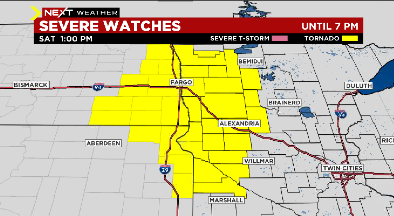
Tornado watch issued until 7 p.m. Saturday (Credit: CBS)
UPDATE (11 a.m.) – A flash flood warning has been issued for Grand Forks and Polk County until 7:45 p.m. on Saturday.
UPDATE (8:15 a.m.) — A severe thunderstorm warning has been issued for parts of Blue Earth, Le Sueur, and Waseca counties until 8:30 a.m. The storm is heading northeast, and if it holds together, could make it to Bloomington and Richfield around 9 a.m.
MINNEAPOLIS (WCCO) — It’s already been plenty wet and rainy this week so far, but another system could bring damaging storms on Saturday, which is why we’re calling a Next Weather Alert day for Saturday.
The potential for some real rumbles begins on Saturday. The day will be much warmer and highs will reach into the 70s, and it’ll be quite humid.
Storms will move through the Twin Cities metro quickly until 11 a.m. Then there will be a break – though it’ll still be windy – before the main round of scattered severe thunderstorms makes its way through in the afternoon.
The biggest threat for the area comes in the form of potentially damaging hail. There’s also a possibility for wind gusts exceeding 50 mph in the southwest portion of the state Saturday. Deep in the southwest corner – from Marshall to Worthington – there is a potential for brush fires to start.
There’s also a flood warning due to a large amount of snow melt in northwestern Minnesota, from Bemidji to Fargo. Also in northern Minnesota, there is a possibility of tornadoes briefly spinning up areas including Bemidji, Alexandria, and Brainerd.
We’ve issued a
NEXT WEATHER ALERT across #MNwx today–our way to alert you to high-impact weather ahead. We’re watching for an aft’n/eve. severe-weather threat (damaging
winds,
hail, and possibly a brief
tornado). @jennifermayerle & I will see you at 8am @WCCO #WIwx pic.twitter.com/ArI7lQmFcr
— Mike Augustyniak (@MikeAugustyniak) April 23, 2022
https://platform.twitter.com/widgets.js
By around 10 p.m. on Saturday evening, the severe weather threat will likely expire.
Next Week
Cooler weather arrives Sunday into next week, and the pattern stays fairly quiet.
That being said, there’s still a likelihood that the next week brings temperatures mostly below average for this time of year. Monday’s high is looking to stall out in the low 40s, with overnight lows early next week hovering around or even below freezing.
Those seeking the comforting rays of sunshine will also find that much of next week is looking more cloudy than not. Once again, April is breaking hearts in Minnesota.
Source: CBS Minnesota


Be First to Comment